Keutschach am See
Jump to navigation
Jump to search
municipality in Klagenfurt-Land District, Carinthia, Austria   | |||||
| Upload media | |||||
| Instance of |
| ||||
|---|---|---|---|---|---|
| Location | Klagenfurt-Land District, Carinthia, Austria | ||||
| Population |
| ||||
| Area |
| ||||
| Elevation above sea level |
| ||||
| official website | |||||
 | |||||
Dobein/Dobajna[edit]
-
 English:
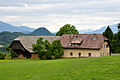
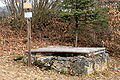
Water wheel in the Dobein forest close to the farmstead KRAINZDeutsch:
Wasserrad im Dobeiner Wald nahe dem Haus KRAINZ -
 English:
BrookDeutsch:
Bach -
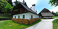
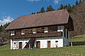
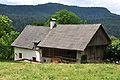
 English:
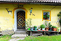
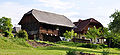
Number 1, barnyard “vulgo KANOUTZ”Deutsch:
Nummer 1, „vulgo KANOUTZ“-Keusche -
 English:
Number 1, barnyard “vulgo KANOUTZ”Deutsch:
Nummer 1, „vulgo KANOUTZ“-Keusche -
 English:
Number 1, barnyard “vulgo KANOUTZ”Deutsch:
Nummer 1, „vulgo KANOUTZ“-Keusche -
 English:
Number 1, barnyard “vulgo KANOUTZ”Deutsch:
Nummer 1, „vulgo KANOUTZ“-Keusche -
 English:
Number 1, barnyard “vulgo KANOUTZ”Deutsch:
Nummer 1, „vulgo KANOUTZ“-Keusche -
 English:
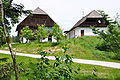
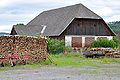
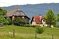
Number 2, farmstead “vulgo TRIEBNIG”Deutsch:
Nummer 2, Keusche „vulgo TRIEBNIG“ -
 English:
Number 5, farmstead “vulgo KRAINZ”Deutsch:
Nummer 5, Keusche „vulgo KRAINZ“ -
 English:
Number 5, farmstead “vulgo KRAINZ”Deutsch:
Nummer 5, Keusche „vulgo KRAINZ“ -
 English:
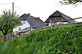
Number 6, farmstead “vulgo DOBEINIGER”Deutsch:
Nummer 6, Keusche „vulgo DOBEINIGER“ -
 English:
Number 7, farmstead “vulgo JAKLITZ”Deutsch:
Nummer 7, Keusche „vulgo JAKLITZ“ -
 English:
Number 8, farmstead “vulgo SPINTIK”Deutsch:
Nummer 8, Keusche „vulgo SPINTIK“ -
 English:
Campsites on the south side of Lake KeutschachDeutsch:
Campingplätze an der Südseite des Keutschacher Sees -
 English:
Campsite SABOTNIK on the southwest side of Lake KeutschachDeutsch:
Campingplatz SABOTNIK an der Südwestseite des Keutschacher Sees -
 English:
Number 9, farmstead "vulgo SABOTNIK"Deutsch:
Nummer 9, Hube „vulgo SABOTNIK“ -
 English:
Number 9, Campingsite "SABOTNIK"Deutsch:
Nummer 9, Campingplatz „SABOTNIK“ -
 English:
Number 10, farmstead "vulgo MÜLLNER"Deutsch:
Nummer 10, Hube „vulgo MÜLLNER“ -
 English:
Number 10, Campingsite "MUELLNER"Deutsch:
Nummer 10, Campingplatz „MÜLLNER“


Dobeinitz/Dobajnica[edit]
-
 English:
Summerlike landscapeDeutsch:
Sommerliche Landschaft -
 English:
"Lake Contrabass"Deutsch:
Bassgeigensee -
 English:
Hibernal "Lake Contrabass"Deutsch:
Bassgeigensee -
 English:
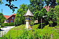
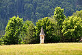
Wayside shrine along the “nature trail bog" in the wetlandsDeutsch:
Wegkreuz am Naturlehrpfad Moor -
 English:
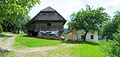
Number 2, farmstead and mill "vulgo KOLLIENZ"Deutsch:
Nummer 2, „vulgo KOLLIENZ"-Hube, Mautmühle und Stampf -
 English:
Number 2, mill "vulgo KOLLIENZ"Deutsch:
Nummer 2, „vulgo KOLLIENZ"-Hube, Mautmühle und Stampf -
 English:
Number 2, stamper in the mill "vulgo KOLLIENZ"Deutsch:
Nummer 2, Stampfe in der Mautmühle der „vulgo KOLLIENZ"-Hube -
 English:
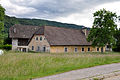
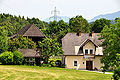
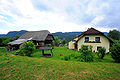
Number 8, farmstead "vulgo GERMITSCH"Deutsch:
Nummer 8, „vulgo GERMITSCH"-Hube -
 English:
Number 9, farmstead "vulgo HOLZER"Deutsch:
Nummer 9, „vulgo HOLZER"-Hube -
 English:
Number 9, barn of the farmstead "vulgo HOLZER"Deutsch:
Nummer 9, Stadel der „vulgo HOLZER"-Hube -
 English:
Number 10, farmstead "vulgo KELLNER"Deutsch:
Nummer 10, „vulgo KELLNER"-Hube -
 English:
Number 10, new house of the farmstead "vulgo KELLNER"Deutsch:
Nummer 10, neues Wohnhaus der „vulgo KELLNER"-Hube


Höflein/Dvorec[edit]
-
 English:
 Rauschelesee (view from the Sattnitz ridge)Deutsch: Rauschelesee (Blick vom Sattnitz-Rücken)
 -
 English:
Rauschelesee (view from the Sattnitz ridge)Deutsch:
Rauschelesee (Blick vom Sattnitz-Rücken) -
 English:
View from the Sattnitz ridgeDeutsch:
Blick von Sattnitz-Rücken -
 English:
View from Sankt NikolaiDeutsch:
Blick von Sankt Nikolai -
 English:
View from PertitschachDeutsch:
Blick von Pertitschach -
 English:
Number 1, farmstead "vulgo KUSCHKER"Deutsch:
Nummer 1, „vulgo KUSCHKER"-Hube -
 English:
Number 2, farmstead "vulgo PISCH"Deutsch:
Nummer 2, „vulgo PISCH"-Hube -
 English:
Number 3, farmstead "vulgo ORDREJ"Deutsch:
Nummer 3, „vulgo ORDREJ"-Hube -
 English:
Number 3, farmstead "vulgo ORDREJ"Deutsch:
Nummer 3, „vulgo ORDREJ"-Hube -
 English:
Number 3, farmstead "vulgo ORDREJ"Deutsch:
Nummer 3, „vulgo ORDREJ"-Hube -
 English:
Number 4, farmstead "vulgo KRAINZ"Deutsch:
Nummer 4, „vulgo KRAINZ"-Hube -
 English:
Number 5, farmstead "vulgo SCHUSCHU"Deutsch:
Nummer 5, „vulgo SCHUSCHU"-Hube -
 English:
Number 5, farmstead "vulgo SCHUSCHU"Deutsch:
Nummer 5, „vulgo SCHUSCHU"-Hube -
 English:
Number 7, farmstead "vulgo SCHAMP"Deutsch:
Nummer 7, „vulgo SCHAMP"-Hube -
 English:
Number 8, farmstead "vulgo KEUTSCHNIG"Deutsch:
Nummer 8, „vulgo KEUTSCHNIG"-Keuschnig -
 English:
Number 27, potteryDeutsch:
Nummer 27, Töpferei


Höhe/Na Gori[edit]
-
 English:
Number 3, farmstead "vulgo Mackek"Deutsch:
Nummer 3, „vulgo Mackek“-Hube -
 English:
Number 4, farmstead "vulgo ANDREJTSCHITSCH" and hotel-restaurantDeutsch:
Nummer 4, „vulgo ANDREJTSCHITSCH“-Hube und Hotel-Restaurant -
 English:
Number 7, farmstead "vulgo DRESCHL"Deutsch:
Nummer 7, „vulgo DRESCHL“-Hube -
 English:
Number 7, farmstead "vulgo DRESCHL"Deutsch:
Nummer 7, „vulgo DRESCHL“-Hube -
 English:
Number 7, farmstead "vulgo DRESCHL"Deutsch:
Nummer 7, „vulgo DRESCHL“-Hube -
 English:
Number 7, detail of the farmstead "vulgo DRESCHL"Deutsch:
Nummer 7, Detail der „vulgo DRESCHL“-Hube -
-
 English:
Number 9, farmstead "vulgo PAULITSCH"Deutsch:
Nummer 9, „vulgo PAULITSCH“-Hube -
 English:
Number 10, farmstead "vulgo Peter"Deutsch:
Nummer 10, „vulgo Peter“-Zulehen -
 English:
Number 11, farmstead "vulgo Lesjak"Deutsch:
Nummer 11, „vulgo Lesjak“-Hube -
 English:
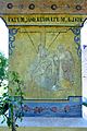
Number 25, private apartment house with frasco by Friedrich Jerina from the year 1981Deutsch:
Nummer 25, privates Wohnhaus mit einem Fresko von Fridrich Jerina aus dem Jahre 1981


Keutschach/Hodiše[edit]
-
 English:
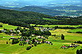
View from the look-out tower on top of the Pyramid BallonDeutsch:
Blick vom Aussichtsturm auf dem Pyramidenkogel -
 English:
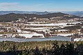
View from Dobein at Keutschach and the lakeDeutsch:
Blick von Dobein auf Keutschach und den See -
 English:
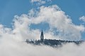
Rectory, parish church and castleDeutsch:
Pfarrhof, Pfarrkirche und Schloss -
 English:
Castle and parish churchDeutsch:
Schloss und Pfarrkirche -
 English:
MaypoleDeutsch:
Maibaum -
 English:
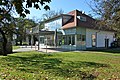
Elementary schoolDeutsch:
Volksschule -
 English:
Wayside shrine on the former main roadDeutsch:
Bildstock an der alten Hauptstraße -
 English:
Number 11, farmstead "vulgo Kuess"Deutsch:
Nummer 11, „vulgo Kuess“-Hube -
 Seentalstraße (Skulptur im Kreisverkehr)


_Mattes_2022-07-18.jpg)
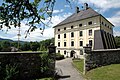
Castle and municipal office | Schloss und Gemeindeamt[edit]
-
 English:
Eastern viewDeutsch:
Ost-Ansicht -
 English:
Northwestern viewDeutsch:
NW-Ansicht -
 English:
Northern viewDeutsch:
Nord-Ansicht -
 English:
Eastern viewDeutsch:
Ost-Ansicht -
 English:
Southern viewDeutsch:
Süd-Ansicht -
 English: Southwestern viewDeutsch: SW-Ansicht
 -
 English:
Southwestern viewDeutsch:
SW-Ansicht -
 English:
Valvasor´s copper engraving "Old castle" from 1688Deutsch:
Valvasors Kupferstich „Altes Schloss“ aus dem Jahre 1688 -
 English:
Valvasor´s copper engraving "New castle" from 1688Deutsch:
Valvasors Kupferstich „Neues Schloss“ aus dem Jahre 1688 -
 English:
Conference room in the castleDeutsch:
Besprechungsraum im Gemeindeamt -
 English:
Conference room for the municipal council in the castleDeutsch:
Sitzungssaal des Gemeinderates im Gemeindeamt


Castle barn | Schlossstadel[edit]
-
 English:
Eastern viewDeutsch:
Ost-Ansicht -
 English:
Eastern viewDeutsch:
Ost-Ansicht -
 English: Western viewDeutsch: West-Ansicht
 -
 English: Western viewDeutsch: West-Ansicht
 -
 English:
Southwestern viewDeutsch:
SW-Ansicht -
 English:
Interior viewDeutsch:
Innenraum


Castle pond | Schlossteich[edit]
-
 English: Eastern viewDeutsch: Ost-Ansicht
 -
 English: Eastern viewDeutsch: Ost-Ansicht


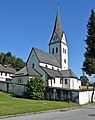
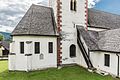
Parish church Saints George and Bartholomew | Pfarrkirche hll. Georg und Bartholomäus[edit]
-
 English: Southeastern viewDeutsch: SO-Ansicht
 -
 English: Northwestern viewDeutsch: NW-Ansicht
 -
 English:
Northwestern viewDeutsch:
NW-Ansicht -
 English:
Northwestern viewDeutsch:
NW-Ansicht -
 English: Western viewDeutsch: West-Ansicht
 -
 English:
Western viewDeutsch:
West-Ansicht -
 English:
Western viewDeutsch:
West-Ansicht -
 English:
Western viewDeutsch:
West-Ansicht -
 English:
Eastern viewDeutsch:
Ost-Ansicht -
 English:
Church tower, north viewDeutsch:
Kirchturm, Nord-Ansicht -
 English:
Church tower, northeastern viewDeutsch:
Kirchturm, NO-Ansicht -
 English:
Church tower, northeastern viewDeutsch:
Kirchturm, NO-Ansicht -
 English:
Western porchDeutsch:
Westliche Vorhalle -
 English:
Western porchDeutsch:
Westliche Vorhalle -
 English:
Southsoutheastern partial view with the lantern of the deadDeutsch:
SSO-Teilansicht mit der gotischen Lichtsäule -
 English:
Eastern view of the Gothic apse and the baroque chapelDeutsch:
Ost-Ansicht der Apsis und des nördlichen Barock-Kapellenabaus -
 English:
Eastern view of the Gothic apse and the baroque chapelDeutsch:
Ost-Ansicht der Apsis und des nördlichen Barock-Kapellenabaus -
 English:
Northern baroque chapelDeutsch:
Nördlicher Barock-Kapellenbau -
 English:
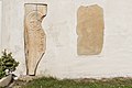
Crucifix, romanesque gravestone with inscription "WLVERS" and pre romanesque carved stone (resurrection symbol?) with blessing cross at the exteriour southern wallDeutsch:
Kruzifix, romanische Grabplatte mit Inschrift „WLVERS“ und vorromanischer Ritzstein (Auferstehungssymbol?) mit Weihekreuzchen an der südlichen Außenwand -
 English:
Romanesque tombstonesDeutsch:
Romanische Grabplatten -
 English:
Romanesque tombstoneDeutsch:
Romanische Grabplatte -
 English:
Romanesque tombstoneDeutsch:
Romanische Grabplatte -
 English:
Romanesque tombstoneDeutsch:
Romanische Grabplatte -
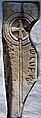
 English: Pre-Romanesque carved stone (resurrection symbol?)Deutsch: Vorromanischer Ritzstein (Auferstehungssymbol?)
 -
 English:
Pre-Romanesque carved stone (resurrection symbol?)Deutsch:
Vorromanischer Ritzstein (Auferstehungssymbol?) -
 English:
Pre-Romanesque carved stone (resurrection symbol?)Deutsch:
Vorromanischer Ritzstein (Auferstehungssymbol?) -
 English:
Sacristy`s south wallDeutsch:
Sakristei-Süd-Wand


Gothic light column | Gotische Lichtsäule[edit]
-
 English:
Southeastern viewDeutsch:
SO-Ansicht -
 English: Southeastern viewDeutsch: SO-Ansicht
 -
 English:
Southeastern viewDeutsch:
SO-Ansicht -
 English:
Southern viewDeutsch:
Süd-Ansicht -
 English: Western viewDeutsch: West-Ansicht
 -
 English:
Western viewDeutsch:
West-Ansicht -
 English:
Northwestern viewDeutsch:
NW-Ansicht -
 English:
Northeastern viewDeutsch:
NO-Ansicht -
 English:
Northeastern viewDeutsch:
NO-Ansicht


#2: Rectory | Nr. 2: Pfarrhof[edit]
-
 English:
Southeastern viewDeutsch:
SO-Ansicht -
 English:
Eastern view and castleDeutsch:
Ost-Ansicht und Schloss -
 English: Western viewDeutsch: West-Ansicht
 -
 English:
Western view (former paint)Deutsch:
West-Ansicht (vormaliger Anstrich) -
 English:
Northwestern view and parish churchDeutsch:
NW-Ansicht und Pfarrkirche


#2: Rectory's barn | Nr. 2: Pfarrstadel[edit]
-
 English:
Southern viewDeutsch:
Süd-Ansicht -
 English: Southern viewDeutsch: Süd-Ansicht
 -
 English:
Western viewDeutsch:
West-Ansicht


Leisbach/Ležbe[edit]
-
 English:
View from the Sattnitz ridge, Ulrichsberg in the backgroundDeutsch:
Blick vom Sattnitz-Rücken, im Hintergrund der Ulrichsberg -
 English:
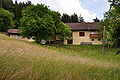
Farm landDeutsch:
Bauernland -
 English:
Number 1, farmstead "vulgo ONIGER"Deutsch:
Nummer 1, „vulgo ONIGER“-Hube -
 English:
Number 2, farmstead "vulgo MAUCHLER"Deutsch:
Nummer 2, „vulgo MAUCHLER“-Hube -
 English:
Number 4, farmstead "vulgo PRIBOS"Deutsch:
Nummer 4, Hube „vulgo PRIBOS“ -
 English:
Number 6, farmstead "vulgo POLZER"Deutsch:
Nummer 6, Hube „vulgo POLZER“ -
 English:
Number 6, farmstead "vulgo POLZER"Deutsch:
Nummer 6, Hube „vulgo POLZER“ -
 English:
Number 6, farmstead "vulgo POLZER" and wayside shrine from the year 1680Deutsch:
Nummer 6, Hube „vulgo POLZER“ und Nischenbildstock aus dem Jahre 1680 -
 English:
Number 8, farmstead "vulgo LAPUSCH"Deutsch:
Nummer 8, „vulgo LAPUSCH“-Hube -
 English:
Number 9, farmstead "vulgo DASETNIG"Deutsch:
Nummer 9, „vulgo DASETNIG“-Hube -
 English:
Number 9, farmstead "vulgo DASETNIG"Deutsch:
Nummer 9, „vulgo DASETNIG“-Hube -
 English:
Number 10, farmstead "vulgo SETZ"Deutsch:
Nummer 10, Wirtschaftsgebäude der „vulgo SETZ“-Hube


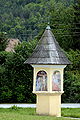
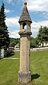
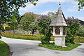
“Polzer Cross” from 1670 | „Polzerkreuz“ aus dem Jahre 1670[edit]
-
 English:
Village center with the wayside shrineDeutsch:
Dorfzentrum mit dem Bildstock -
 English:
South west viewDeutsch:
Südwest-Ansicht -
 English:
South east viewDeutsch:
Südost-Ansicht -
 English:
South east viewDeutsch:
Südost-Ansicht -
 English:
North viewDeutsch:
Nord-Ansicht -
 English:
East viewDeutsch:
Ost-Ansicht -
 English:
Alcove painting of Christ on the Mount of Olives on the east sideDeutsch:
Nischenmalerei von Christus am Ölberg auf der Ostseite -
 English:
Trinity fresco on the south sideDeutsch:
Dreifaltigkeits-Malerei auf der Südseite -
 English:
Alcove painting of crucifixion on the north sideDeutsch:
Nischenmalerei der Kreuzigung auf der Nordseite -
 English:
Alcove painting of crucifixion on the north sideDeutsch:
Nischenmalerei der Kreuzigung auf der Nordseite -
 English:
Alcove painting of the 7th station of the cross on the west sideDeutsch:
Nischenmalerei der 7. Station des Kreuzweges auf der Westseite -
 English:
Painting of Saint Christopher on the douth sideDeutsch:
Malerei Heiligen Christopherus auf der Südseite -
 English:
Drawing and painting of Flagellation of Christ on the east sideDeutsch:
Malerei und Zeichnung der Geißelung von Christus auf der Ostseite -
 English:
Drawing and painting of Pietà on the north sideDeutsch:
Malerei und Zeichnung der Pietà auf der Nordseite -
 English:
Drawing and painting of Crowning with Thorns on the west sideDeutsch:
Malerei und Zeichnung der Krönung mit Dornen auf der Westseite


Linden/Lipa[edit]
-
 English:
Number 20, restaurant "Karawankenblick"Deutsch:
Nummer 20, Restaurant „Karawankenblick“ -
 English:
Number 1, farmstead "vulgo OBUD"Deutsch:
Nummer 1, „vulgo OBUD“-Hube -
 English:
Number 4, farmstead "vulgo Widitsch", number 8 "vulgo Matheuschitz" and number 9 barnyard "vulgo Tuloutz"Deutsch:
Nummer 4, „vulgo Widitsch"-Hube, Nr. 8 „vulgo Matheuschitz“-Hube und Nr. 9 „vulgo Tuloutz“ -
 English:
Number 5, farmstead "vulgo ERBUTSCHNIG", domain WaisenbergDeutsch:
Nummer 5, „vulgo ERBUTSCHNIG“, Herrschaft Waisenberg -
 English:
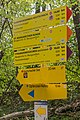
Number 6, Wegweiser am Wanderweg zum PyramidenkogelDeutsch:
Nummer 6, signposts on the hiking trail to the Mount Pyramid -
 English:
Bildstock am Wanderweg zum PyramidenkogelDeutsch:
Wayside shrine on the hiking trail to the Mount Pyramid -
 English:
Number 6, farmstead "vulgo HODRIAN"Deutsch:
Nummer 6, „vulgo HODRIAN“-Hube -
 English:
Number 7, farmstead "vulgo Brachulnik"Deutsch:
Nummer 7, „vulgo Brachulnik“-Hube -
 English:
Number 7, farmstead "vulgo Brachulnik"Deutsch:
Nummer 7, „vulgo Brachulnik“-Hube


Pertitschach/Prtiče[edit]
-
English:
View from the Sattnitz ridgeDeutsch:
Blick vom Sattnitz-Rücken -
 English:
Number 2, farmstead “vulgo Kuess“Deutsch:
Nummer 2, Anwesen „vulgo Kuess“ -
 English:
Number 3, farmstead “vulgo Ostermann“Deutsch:
Nummer 3, Anwesen „vulgo Ostermann“ -
 English:
Number 3, farmstead “vulgo Ostermann“Deutsch:
Nummer 3, Anwesen „vulgo Ostermann“ -
 English:
Wayside shrine and behind number 4, the farmstead “vulgo Trampusch“Deutsch:
Bildstock und dahinter Nummer 4, das Anwesen „vulgo Trampusch“ -
 English:
Number 4, farmstead “vulgo Trampusch“Deutsch:
Nummer 4, Anwesen „vulgo Trampusch“ -
 English:
Number 5, farmstead “vulgo Zwander“Deutsch:
Nummer 5, Anwesen „vulgo Zwander“ -
 English:
SawmillDeutsch:
Sägewerk


Plaschischen/Plašišče[edit]
Roundabout | Kreisverkehr[edit]
-
 English:
Northwestern viewDeutsch:
NW-Ansicht -
 English:
Northwestern viewDeutsch:
NW-Ansicht -
 English:
Finger postsDeutsch:
Wegweiser


#9: Residential building | Nr. 9: Wohnhaus[edit]
-
 English:
Southern viewDeutsch:
Süd-Ansicht

#21: Residential building | Nr. 21: Wohnhaus[edit]
-
 English:
Eastern viewDeutsch:
Ost-Ansicht

#27: Residential building | Nr. 27: Wohnhaus[edit]
-
 English:
Ssouthern viewDeutsch:
Süd-Ansicht -
 English:
Northwestern viewDeutsch:
NW-Ansicht


Forest hiking trail | Waldwanderweg[edit]
-
 English:
ForestDeutsch:
Wald -
 English:
ForestDeutsch:
Wald -
 English:
ForestDeutsch:
Wald -
 English:
ForestDeutsch:
Wald -
 English:
ForestDeutsch:
Wald -
 English:
ForestDeutsch:
Wald -
 English:
ForestDeutsch:
Wald -
 English:
ForestDeutsch:
Wald -
 English:
ForestDeutsch:
Wald -
 English:
ForestDeutsch:
Wald -
 English:
FingerpostsDeutsch:
Wegweiser -
 English:
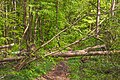
Fallen treesDeutsch:
Umgestürzte Bäume -
 English:
Fallen treesDeutsch:
Umgestürzte Bäume -
 English:
ForestDeutsch:
Wald -
 English:
ForestDeutsch:
Wald -
 English:
ForestDeutsch:
Wald -
 English:
Fallen treesDeutsch:
Umgestürzte Bäume


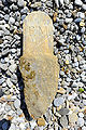
Offering rock | Opferstein ("Hexenstein")[edit]
-
 English:
FingerpostsDeutsch:
Wegweiser -
 English:
Forest hiking trail at the offering rockDeutsch:
Waldwanderweg am Opferstein -
 English:
PlaqueDeutsch:
Tafel -
 English:
Northwestern viewDeutsch:
NW-Ansicht -
 English:
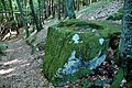
CupmakDeutsch:
Schale -
 English:
CupmakDeutsch:
Schale -
 English:
Southeastern viewDeutsch:
SO-Ansicht -
 English:
Southern viewDeutsch:
Süd-Ansicht -
 English:
Northwestern viewDeutsch:
NW-Ansicht -
 English:
Northern viewDeutsch:
Nord-Ansicht -
 English:
Northern viewDeutsch:
Nord-Ansicht -
 English:
Northern viewDeutsch:
Nord-Ansicht


Miscellaneous | Verschiedenes[edit]
-
 English:
View from Pyramid BallonDeutsch:
Blick vom Pyramidenkogel -
 English:
View from Pyramid BallonDeutsch:
Blick vom Pyramidenkogel -
 English:
Reifnitz brookDeutsch:
Reifnitzbach -
 English:
Number 54, Lido on the Keutschacher SeeDeutsch:
Nummer 54, Strandbad am Keutschacher See -
 English:
Alders on the peninsula of the lido on the Keutschacher SeeDeutsch:
Erlen auf der Halbinsel im Strandbad am Keutschacher See -
 English:
Number 2, farmstead "vulgo PETRITZ"Deutsch:
Nummer 2, „vulgo PETRITZ"-Hube -
 English:
Number 2, farmstead "vulgo PETRITZ"Deutsch:
Nummer 2, „vulgo PETRITZ"-Hube -
 English:
Number 3, farmstead "vulgo LIENDL" (right hand) and number #4, farmstead "vulgo LEDERER" (left hand)Deutsch:
Nummer 3, „vulgo LIENDL"-Hube (rechts im Bild) und Nummer 4, „vulgo LEDERER"-Keusche (links im Bild) -
 English:
Number 3, farmstead "vulgo LIENDL" (right hand) and number #4, farmstead "vulgo LEDERER" (left hand)Deutsch:
Nummer 3, „vulgo LIENDL"-Hube (rechts im Bild) und Nummer 4, „vulgo LEDERER"-Keusche (links im Bild) -
 English:
Number 5, restaurant "vulgo BRÜCKLER"Deutsch:
Nummer 5, „vulgo BRÜCKLER"-Restaurant -
 English:
Number 5, restaurant "vulgo BRÜCKLER"Deutsch:
Nummer 5, „vulgo BRÜCKLER"-Restaurant -
 English:
Number 6, farmstead "vulgo WUNKOUTZ"Deutsch:
Nummer 6, „vulgo WUNKOUTZ"-Hube -
 English:
Number 6, farmstead "vulgo WUNKOUTZ"Deutsch:
Nummer 6, „vulgo WUNKOUTZ"-Hube -
 English:
Number 8, farmstead "vulgo KIRSCHNER"Deutsch:
Nummer 8, „vulgo KIRSCHNER"-Hube -
 English:
Number 9, farmstead "vulgo KAUFITSCH"Deutsch:
Nummer 9, „vulgo KAUFITSCH"-Hube -
 English:
Number 13, forge and blacksmith Paulitsch "vulgo NAGELSCHMIED"Deutsch:
Nummer 13, Schmiede und Schlosserei „vulgo NAGELSCHMIED"-Keusche -
 English:
Number 60, cottage "Scherling"Deutsch:
Nummer 60, Landhaus „Scherling“ -
 English:
Wayside shrine on the roundabout to the PyramidenkogelDeutsch:
Bildstock am Kreisverkehr zum Pyramidenkogel -
 English:
Wayside shrine on the roundabout to REifnitzDeutsch:
Bildstock am Kreisverkehr nach Reifnitz


Plescherken/Plešerka[edit]
-
 English:
Winterly landscape on the east shore of the Lake HafnerDeutsch:
Winterliche Landschaft am Ostufer des Hafnersees -

-
 English:
Number 1, farmstead “vulgo Mratschnigger”Deutsch:
Nummer 1, Hube „vulgo Mratschnigger“ -
 English:
Number 4, farmstead “vulgo KURNIG”Deutsch:
Nummer 4, „vulgo KURNIG“-Hube -
 English:
Number 6, farmstead “vulgo SUETE", guest house and restaurant AlleschDeutsch:
Nummer 6, „vulgo SUETE“-Hube, Pension und Restaurant Allesch -
 English:
Number 7, farmstead “vulgo MOKRI”Deutsch:
Nummer 7, „vulgo MOKRI“-Hube -
 English:
Number 8, farmstead “vulgo STRGANTSCHNIG”Deutsch:
Nummer 8, „vulgo STRGANTSCHNIG“-Hube -
 English:
Number 10, farmstead “vulgo VEIT”Deutsch:
Nummer 10, „vulgo VEIT“-Keusche -
 English:
Number 11, farmstead “vulgo RINKISCH”Deutsch:
Nummer 11, „vulgo RINKISCH“-Zulehen -
 English:
Number 13, farmstead “vulgo JÄGER”Deutsch:
Nummer 13, „vulgo JÄGER“-Zulehen -
 English:
Number 15, farmstead “vulgo KOSMITSCH”Deutsch:
Nummer 15, „vulgo KOSMITSCH“-Keusche -
 English:
Number 57, apartment house “fisherman`s hut”Deutsch:
Nummer 57, „Fischerhütte“ -
 English:
Number 80, “Café Restaurant Alt Wien”Deutsch:
Nummer 80, „Café Restaurant Alt Wien“


Rauth/Rut[edit]
-
 English:
Rauth #30 (white building) amd Rauth #32 (yellow house)Deutsch:
Rauth 30 (weißes Haus) und Rauth 32 (gelbes Wohnhaus) -
 English:
Alcove wayside shrine at the side road to RauthDeutsch:
Nischenbildstock an der Straßenabzweigung nach Rauth -
 English:
Alcove wayside shrine at the side road to RauthDeutsch:
Nischenbildstock an der Straßenabzweigung nach Rauth -
 English:
Number 1, farmstead "vulgo SCHAWARZ"Deutsch:
Nummer 1, Hube „vulgo SCHAWARZ“ -
 English:
Number 2, farmstead "vulgo STAUPITZ", owners: family SetzDeutsch:
Nummer 2, Hube „vulgo STAUPITZ“, Besitzer: Familie Setz -
 English:
Wall painting on number 2, farmstead "vulgo STAUPITZ", owners: family SetzDeutsch:
Wandmalerei am Haus der Nummer 2, Hube „vulgo STAUPITZ“, Besitzer: Familie Setz -
 English:
Wall painting (by Prof. E. Pirker from August 1985) on number 2, farmstead "vulgo STAUPITZ", owners: family SetzDeutsch:
Wandmalerei (von Prof. E. Pirker vom August 1985) am Haus der Nummer 2, Hube „vulgo STAUPITZ“, Besitzer: Familie Setz -
 English:
Wooden gate to the vineyard of "vulgo STAUPITZ"Deutsch:
Holzgatter zum Weinberg von "vulgo STAUPITZ" -

-
 English:
Vineyard of "vulgo STAUPITZ" on the south acclivityDeutsch:
Weinberg am Süd-Hang von "vulgo STAUPITZ" -

-
 English:
Number 3, farmstead "vulgo PUNTSCHART" (west view)Deutsch:
Nummer 3, Hube „vulgo PUNTSCHART“ (West-Ansicht) -
 English:
Number 3, farmstead "vulgo PUNTSCHART" (south view)Deutsch:
Nummer 3, Hube „vulgo PUNTSCHART“ (Süd-Ansicht) -
 English:
Number 4, farmstead "vulgo DERMALZ"Deutsch:
Nummer 4, „vulgo DERMALZ“-Hube -
 English:
Number 4, farmstead "vulgo DERMALZ"Deutsch:
Nummer 4, „vulgo DERMALZ“-Hube -
 English:
Number 4, entrance door to the farmstead "vulgo DERMALZ"Deutsch:
Nummer 4, Eingang zum Bauernhuas der „vulgo DERMALZ“-Hube -
 English:
Number 6, barn of the farmstead "vulgo PIBER"Deutsch:
Nummer 6, Wirtschaftsgebäude von „vulgo PIBER“ -
 English:
Number 6, farmstead "vulgo PIBER" (built in 1723)Deutsch:
Nummer 6, Zulehen „vulgo PIBER“ (erbaut 1723) -
 English:
Engraving of crucifixion on top of the portal to the farmstead "vulgo PIBER" at Rauth #6Deutsch:
Relief der Kreuzigungsgruppe über dem Eingang zum Haus in Rauth 6 -
 English:
Alcove wayside shrine close to farmstead "vulgo PIBER"Deutsch:
Nischenbildstock nahe dem Bauernhaus „vulgo PIBER“ -
 English:
Punschart pond in a landscape protection areaDeutsch:
Punschartteich im Landschaftsschutzgebiet -
 English:
Boundary stone close to the Punschart pondDeutsch:
Grenzstein nahe dem Punschartteich


Reauz/Rjavec[edit]
-

-

-

-
 English:
Boundary stone of the regional court Leisbach next to “vulgo Nemetz”, 1763 - borderline to ViktringDeutsch:
Grenzstein des LG Leisbach beim „vulgo Nemetz“, 1763 - Grenzlinie zu Viktring -
 English:
Boundary stone with the initials F.M. Fratelli MoroDeutsch:
Grenzstein mit den Initialen F.M. Fratelli Moro -
 English:
Number 1, bath "vulgo MÜLLNER"Deutsch:
Nummer 1, Strandbad „vulgo MÜLLNER“ -
 English:
Number 2, farmstead "vulgo PITSCHEK", owner: Herbert SchrottDeutsch:
Nummer 2, „vulgo PITSCHEK“-Keusche, Besitzer: Herbert Schrott -
 English:
Number 3, hotel and restaurant, farmstead "vulgo RAUSCH", owner: family ReichenhauserDeutsch:
Nummer 3, Hotel-Restaurant „vulgo RAUSCH“-Hube, Besitzer: Familie Reichenhauser -
 English:
Number 3, hotel and restaurant, farmstead "vulgo RAUSCH", owner: family ReichenhauserDeutsch:
Nummer 3, Hotel-Restaurant „vulgo RAUSCH“-Hube, Besitzer: Familie Reichenhauser -
 English:
Number 4, farmstead "vulgo REAUTSCHNIG" and campsite, owner: Mrs. Anna Maria SimaDeutsch:
Nummer 4, „vulgo REAUTSCHNIG“-Hube und Campingplatz, Besitzerin: Anna Maria Sima -
 English:
Cotton grass in a marsh areaDeutsch:
Wollgras in einer Feuchtwiese -
 English:
Number 5, farmstead "vulgo POTROBISCH" and “campsite Reichmann”, owner: Mr. Robert ReichmannDeutsch:
Nummer 5, „vulgo POTROBISCH“-Hube und „Campingplatz Reichmann“, Besitzer: Robert Reichmann -
 English:
Number 5, farmstead "vulgo POTROBISCH" and “campsite Reichmann”, owner: Mr. Robert ReichmannDeutsch:
Nummer 5, „vulgo POTROBISCH“-Hube und „Campingplatz Reichmann“, Besitzer: Robert Reichmann -
 English:
No. 5, campsite ReichmannDeutsch:
Nr. 5, Campingplatz Reichmann -
 English:
No. 5, campsite ReichmannDeutsch:
Nr. 5, Campingplatz Reichmann -
 English:
No. 5, campsite ReichmannDeutsch:
Nr. 5, Campingplatz Reichmann -
 English:
No. 5, campsite ReichmannDeutsch:
Nr. 5, Campingplatz Reichmann -
 English:
Number 6, farmstead "vulgo ZIEGLER"Deutsch:
Nummer 6, „vulgo ZIEGLER“-Zulehen -
 English:
Number 6, farmstead "vulgo ZIEGLER"Deutsch:
Nummer 6, „vulgo ZIEGLER“-Zulehen -
 English:
Number 11, farmstead "vulgo EOBAS"Deutsch:
Nummer 11, „vulgo ROBAS“-Hube -
 English:
Number 15, “SEISER-Keusche” -
 English:
Number 51, villaDeutsch:
Nummer 51, Villa -
 English:
No. 117, Viktring brookDeutsch:
Nr. 117, Viktringer Bach -
 English:
going rack and ruin farmsteadDeutsch:
verfallendes Bauernhaus -
 English:
going rack and ruin farmsteadDeutsch:
verfallendes Bauernhaus -
 English:
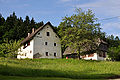
older farmsteadDeutsch:
älteres Bauernhaus


Sankt Margarethen/Šmarjeta[edit]
Subsidiary church Saint Margaret | Filialkirche hl. Margarethe[edit]
-
 English:
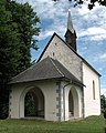
Subsidiary church Saint MargaretDeutsch:
Filialkirche hl. Margaretha -
 English:
Subsidiary church Saint MargaretDeutsch:
Filialkirche hl. Margaretha -
 English:
Subsidiary church Saint MargaretDeutsch:
Filialkirche hl. Margaretha -
 English:
Apse window of the subsidiary church Saint MargaretDeutsch:
Apsisfenster der Filialkirche hl. Margaretha


Wayside shrine | Bildstock[edit]
-
 English:
Wayside shrine before the restoration in the year 2009Deutsch:
Bildstock vor der Renovierung im Jahre 2009 -
 English:
Wayside shrine after the restoration in the year 2009Deutsch:
Bildstock nach der Renovierung im Jahre 2009 -
 English:
Wayside shrine: Painting of Saint George, the dragon killer (was replaced by the Saint Margaret-motif during the renovation 2009)Deutsch:
Bildstock: Bildnis des Heiligen Georg der Drachentöter (wurde während der Restaurierung im Jahre 2009 durch das Heilige Margarethe-Motiv ersetzt) -
 English:
Wayside shrine: Painting of Holy Margaret with the dragonDeutsch:
Bildstock: Bildnis der Heiligen Margarethe mit dem Drachen -
 English:
Wayside shrine: Dragon seal (purged by ignorance during the renovation in 2009)Deutsch:
Bildstock: Drachensiegel (wurde aus Ignoranz während der Renovierung 2009 eliminiert)


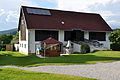
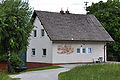
#8: Residential building Dwornig | Nr. 8: Wohnhaus Dwornig[edit]
-
 English:
Number 8, farmstead "vulgo WORNIG"Deutsch:
Nummer 8, „vulgo WORNIG“-Hube -
 English:
Number 8, farmstead "vulgo WORNIG"Deutsch:
Nummer 8, „vulgo WORNIG“-Hube


Miscellaneous | Diverses[edit]
-
 English:
Watch tower of the castle ReifnitzDeutsch:
Wachturm der Burgruine Reifnitz -
 English:
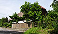
Number 23, guest house "Haus Sophie"Deutsch:
Nummer 23, „Haus Sophie“


St. Nikolai/Šmiklavž[edit]
Subsidiary church Saint Nicholas | Filialkirche hl. Nikolaus[edit]
-
 English:
Southwestern viewDeutsch:
SW-Ansicht -
 English:
Southwestern viewDeutsch:
SW-Ansicht -
 English:
Southwestern viewDeutsch:
SW-Ansicht -
 English:
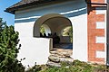
PorchDeutsch:
Vorhalle -
 English:
PorchDeutsch:
Vorhalle -
 English:
PortalDeutsch:
Portal -
 English:
StoupDeutsch:
Weihwasserbecken -
 English:
Open air altarDeutsch:
Feldaltar -
 English:
Southeastern viewDeutsch:
SO-Ansicht -
 English:
Southeastern viewDeutsch:
SO-Ansicht -
 English:
ApseDeutsch:
Chorschluss -
 English:
Gothic window at the apseDeutsch:
Gotisches Fenster am Chorschluss


Miscellaneous | Diverses[edit]
-
-
 English:
HamletDeutsch:
Weiler -
 English:
Pit for flax-processing (no longer in use)Deutsch:
Brechlgrube für die Flachsbearbeitung (nicht mehr in Gebrauch) -
 English:
#1: Farmstead "vulgo GORITSCHNIG"Deutsch:
Nr. 1: „vulgo GORITSCHNIG“-Hube -
 English:
Number 2, farmstead "vulgo SPREIZ"Deutsch:
Nummer 2, „vulgo SPREIZ“-Keusche -
 English:
Number 3, farmstead "vulgo KOPITAR"Deutsch:
Nummer 3, „vulgo KOPITAR“-Hube -
 English:
HaflingerDeutsch:
Haflinger -
 English:
HaflingerDeutsch:
Haflinger


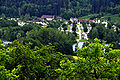
Schelesnitz/Železnica[edit]
-
 English:
View at the Lake Keutschach" -
 English:
Number 1, farmstead “vulgo PUST”Deutsch:
Nummer 1, „vulgo PUST“-Hube -
 English:
Number 1, farmstead “vulgo PUST”Deutsch:
Nummer 1, „vulgo PUST“-Hube -
 English:
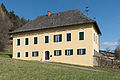
Number 2, farmstead “vulgo SCHWARZ"Deutsch:
Nummer 2, „vulgo SCHWARZ“-Hube -
 English:
Number 4, farmstead “vulgo TSCHEBER"Deutsch:
Nummer 4, „vulgo TSCHEBER“-Hube -
 English:
Number 5, apartment houseDeutsch:
Nummer 5, Wohnhaus -
 English:
Number 15, apartment houseDeutsch:
Nummer 15, Wohnhaus


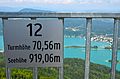
Pyramid Ballon | Pyramidenkogel[edit]
General view | Gesamtansicht[edit]
-
 English:
Northeastern viewDeutsch:
NO-Ansicht

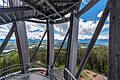
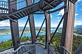
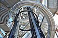
Look-out tower #3 since 2013 | Aussichtsturm 3 ab 2013[edit]
-
 English:
Northern viewDeutsch:
Nord-Ansicht -
 English:
Eastern viewDeutsch:
Ost-Ansicht -
 English:
Northern viewDeutsch:
Nord-Ansicht -
 English:
Eastern viewDeutsch:
Ost-Ansicht -
 English:
Eastern viewDeutsch:
Ost-Ansicht -
 English:
Presentation plaqueDeutsch:
Darstellungs-Tafel -
 English:
Presentation plaqueDeutsch:
Darstellungs-Tafel -
 English:
Northeastern viewDeutsch:
NO-Ansicht -
 English:
Northeastern viewDeutsch:
NO-Ansicht -
 English:
Northeastern viewDeutsch:
NO-Ansicht -
 English:
Northeasernt viewDeutsch:
NO-Ansicht -
 English:
Northeastern viewDeutsch:
NO-Ansicht -
 English:
Cut-out from the baseDeutsch:
Ausschnitt von der Basis -
 English:
StaircaseDeutsch:
Treppe -
 English:
Construction detailDeutsch:
Konstruktionsdetail -
 English:
StaircaseDeutsch:
Treppe -
 English:
Dry slide and staircasesDeutsch:
Trockenrutsche und Treppen -
 English:
Dry slide and staircasesDeutsch:
Trockenrutsche und Treppen -
 English:
StaircaseDeutsch:
Treppe -
 English:
StaircaseDeutsch:
Treppe -
 English:
Construction detailDeutsch:
Ausschnitt von der Konstruktion -
 English:
Construction detailDeutsch:
Ausschnitt von der Konstruktion -
 English:
Construction detailDeutsch:
Ausschnitt von der Konstruktion -
 English:
Construction detailDeutsch:
Ausschnitt von der Konstruktion -
 English:
Construction detailDeutsch:
Ausschnitt von der Konstruktion -
 English:
Construction detailDeutsch:
Ausschnitt von der Konstruktion -
 English:
Dry slide and staircasesDeutsch:
Trockenrutsche und Treppen -
 English:
Dry slide and staircasesDeutsch:
Trockenrutsche und Treppen -
 English:
Dry slide and staircasesDeutsch:
Trockenrutsche und Treppen -
 English:
Dry slide and staircasesDeutsch:
Trockenrutsche und Treppen -
 English:
Dry slide and staircasesDeutsch:
Trockenrutsche und Treppen -
 English:
Cutout from the staircaseDeutsch:
Ausschnitt von der Treppe -
 English:
Dry slide and staircasesDeutsch:
Trockenrutsche und Treppen -
 English:
Oak staircase to the skyboxDeutsch:
Eichentreppe zur verglasten Plattform -
 English:
Staircase in the skyboxDeutsch:
Treppen innerhalb der verglasten Plattform -
 English:
SkyboxDeutsch:
Verglaste Plattform -
 English:
Visitors on the highest platformDeutsch:
Besucher auf der höchsten Plattform -
 English:
Communications mastDeutsch:
Sendemast -
 English:
Refracting telescopeDeutsch:
Fernrohr -
 English:
Plaque on the highest platform for visitorsDeutsch:
Info-Tafel auf der obersten Besucher-Plattform -
 English:
Plaque on the highest platform for visitorsDeutsch:
Info-Tafel auf der obersten Besucher-Plattform -
 English:
Sunshades at the open-air restaurantDeutsch:
Sonnenschirme des Freiluft-Restaurants -
 English:
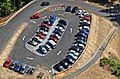
Parking lotDeutsch:
Parkplatz -
 English:
Parking lotDeutsch:
Parkplatz -
 English:
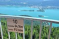
View at PoertschachDeutsch:
Blick auf Pörtschach -
 English:
View at PoertschachDeutsch:
Blick auf Pörtschach -
 English:
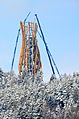
New look-out tower (constructed 2013)Deutsch:
Neuer Aussichtsturm (erbaut 2013) -
 English:
New look-out tower (constructed 2013)Deutsch:
Neuer Aussichtsturm (erbaut 2013) -
 English:
Construction works on the new look-out tower (2013)Deutsch:
Bau des neuen Aussichtsturms (2013) -
 English:
Construction works on the new look-out tower (2013)Deutsch:
Bau des neuen Aussichtsturms (2013) -
 English:
Construction works on the new look-out tower (2013)Deutsch:
Bau des neuen Aussichtsturms (2013)


Look-out tower #2 from 1967 to 2012 | Aussichtsturm 2 von 1967 bis 2012[edit]
-
 English:
Look-out tower (1967-2012)Deutsch:
Aussichtsturm (1967-2012) -
 English:
Look-out tower (1967-2012)Deutsch:
Aussichtsturm (1967-2012) -
 English:
View at the Lake Woerth from the platform of the second look-out tower (1967-2012)Deutsch:
Blick auf den Wörthersee von der Plattform des zweiten Aussichtsturms (1967-2012)


Lakes and ponds/Seen und Teiche[edit]
-
 English:
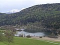
Lake KeutschachDeutsch:
Keutschacher See -
 English:
Lake KeutschachDeutsch:
Keutschacher See -
English:
Reeds and alders on the eastern shore of Lake KeutschachDeutsch:
Erlengruppe hinter Schilf am östlichen Seeufer des Keutschacher Sees -
 English:
North foehn mood upon Lake KeutschachDeutsch:
Nordföhn-Stimmung über dem Keutschacher See -
 English:
North foehn mood upon the hibernal Lake KeutschachDeutsch:
Nordföhn-Stimmung über dem winterlichen Keutschacher See -
 English:
Eastern lakeshore of the Keutschacher See at DobeinitzDeutsch:
Östliches Seeufer des Keutschacher Sees in Dobeinitz -
 English:
Lake Keutschach at SchelesnitzDeutsch:
Keutschacher See in Schelesnitz -
 English:
Pond in KeutschachDeutsch:
Teich in Keutschach -
-
 English:
Rauschelesee in spring-timeDeutsch:
Rauschelesee im Frühling -
 English:
Rauschelesee in winterDeutsch:
Rauschelesee im Winter -
 English:
Lake contrabassDeutsch:
Baßgeigensee -
English:
HafnerseeDeutsch:
Hafnersee -
English:
On the east-shore of the HafnerseeDeutsch:
Am Ostufer des Hafnersees -
English:
Punschart pond in a landscape protection areaDeutsch:
Punschartteich im Landschaftsschutzgebiet


Moorland, bog, swamp | Moor, Sumpf, Feuchtwiesen[edit]
-
 English:
Nature teaching trail bog plaque at DobeinitzDeutsch:
Naturlehrpfad Moor Hinweisschild in Dobeinitz -
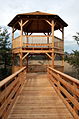 English:
Wooden look-out for watching the wetlands of DobeinitzDeutsch:
Holzwarte in den Moorauen Dobeinitz -
 English:
Wooden look-out for watching the wetlands of DobeinitzDeutsch:
Holzwarte in den Moorauen Dobeinitz -
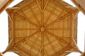 English:
Roof construction of the wooden look-out for watching the wetlands of DobeinitzDeutsch:
Dachkonstruktion der Holzwarte in den Moorauen Dobeinitz


Insignia and maps/Wappen und Karten[edit]
-
 Coat of arms
 -
 Location within Carinthia
 -
 Keutschach (7) within the district Klagenfurt Land

